It was the perfect storm. During one week in the summer of 2002, more than 35 inches of rain fell in the upper watershed of the Guadalupe River, setting off a torrent of floodwater that carved a perfectly fascinating geological wonder—the Canyon Lake Gorge—out of the earth.
A flood of biblical proportions roared through the Hill Country northwest of New Braunfels, tearing away soil, ripping up huge trees, crumpling houses and sending a rush of water from swollen Canyon Lake over its spillway for the first time since the reservoir was completed in 1964.
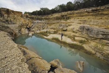
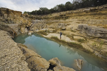
The historic flood sliced open the ground below the spillway, creating a gigantic 64-acre gorge and exposing ancient, crustaceous limestone, fossils and even dinosaur footprints 110 million years old.
Here’s how it happened:
June 28, 2002: A low-pressure system moved east from Mexico and met another weather system coming south over the Hill Country. The heavens broke apart, and for the next week rain fell and fell, with the 35 inches-plus deluge almost equaling the Hill Country’s average yearly rainfall.
Floodwater from myriad creeks and rivers raced down to fill Canyon Lake. As the lake rose, soggy holiday campers were evacuated, and parks were closed. Still the rain came.
July 4, 2002: At 3:30 p.m., a seemingly endless wall of water began blasting over the spillway, tearing out truck-sized boulders, the road, full-grown oak trees and everything else downstream from the spillway. Imagine if you can an avalanche of water flowing at the rate of 67,000 cubic feet per second, pushing huge chunks of limestone downstream. The water that flowed over the spillway—about 185 billion gallons in total—would’ve filled the lake 1 1/2 times at its normal level. The flood crested at 11 a.m. on July 6, and for the next six weeks, water flowed over the spillway, scouring through sedimentation and gouging out so much rock and dirt that the debris would have created a 30-story-tall building the size of a football field.
August 2002: What was once a gentle depression covered with a tangle of oaks, cedars and native brush is now a gorge roughly 1,000 feet wide and 45 feet deep.
It is a textbook example highlighting Hill Country geology and the exposed Trinity Aquifer, clearly showing faults, fractures and seeps in the limestone. Limestone layers created from an ancient sea are visible, and visitors admire waterfalls and springs where the aquifer is exposed.
The gorge is a real-life classroom in which visitors learn how the aquifer’s underground permeable rock cavities soak up and store the rainwater that San Antonio and other cities depend upon for drinking water.
Geologists and oil company representatives come to study the faults and fracturing of the gorge’s limestone.
And the gorge gives hikers an opportunity to explore dinosaur tracks and perfectly preserved fossils, exposed for the first time in millions of years. Fossilized sea urchins are so perfectly preserved that one can see the spines and the minute seams along the creatures’ bodies. One can even see fossilized ocean ripples in the limestone.
2005: After the revelation of this geological phenomenon, local residents banded together to preserve the gorge and its wonders. In 2005, they formed the Gorge Preservation Society (GPS) and partnered with the Guadalupe-Blanco River Authority and the U.S. Army Corps of Engineers to safeguard the gorge and spread the word.
Summer 2008: The nonprofit GPS and its volunteers are in full swing. The society’s dedicated members hack away at invasive plants, patrol for litter, sweep out dinosaur tracks and protect fossils revealed by the flood.
Regular tours are conducted by knowledgeable volunteers who are eager to identify native plants, such as a blooming river primrose, or the track from a sauropod (dinosaur). Starting at the spillway and progressing deeper into the gorge, the tour is exclusively for energetic and fit hikers. Patient guides carefully point hikers to the safest routes, but visitors still scramble up and down rocks and boulders and along ledges as the tour descends into the gorge.
Along the way, the guides point out the tracks of the acrocanthosaurus, a predator cousin of the T. rex, and its prey, the sauropod. It’s life-and-death drama preserved in stone. More fossils are identified. Countless lentil-bean-sized fossils of shelled protozoa are observed.
Visitors spot fish, tadpoles, frogs and crawfish in aqua-blue, spring-fed pools. A lush field of river fern grows beneath the ubiquitous ashe juniper, aka the Hill Country scourge, the pollen source for cedar fever. One feels far removed from 21st-century life.
Water seeps through cracks in limestone and provides an excellent view of how water is transported through the aquifer system. Perhaps this is the most important lesson of the gorge: We must protect the aquifer as the precious resource that it most assuredly is.
——————–
Suzi Sands is art director for Texas Co-op Power.


