We drove to the end of the blacktop, where FM 170—El Camino del Rio, or the storied River Road—abruptly stopped on the northern edge of Candelaria, a dusty village that lies forgotten in the Chihuahuan Desert of far West Texas.
For roughly 120 miles, the pavement’s two yellow stripes seem to flick like a snake’s forked tongue, testing every sharp curve and every steep climb as the two-lane road slithers through mountains, canyons and desert in one of the most rugged and remote parts of Texas. FM 170 starts in Study Butte, where it intersects with State Highway 118, and heads west before cutting northwest through Big Bend Ranch State Park, hugging the Rio Grande between Lajitas and Presidio and making its final run on a desolate stretch guarded by roadrunners and spiny-fingered ocotillo plants.
Breathtaking. Stupendous. Spectacular. Adjectives come so easy, yet seem so inadequate in describing a road that “may well be the prettiest drive in America,” National Geographic declared in 1985. On the River Road, known as Muerte del Burro (Death of the Burro) before it was paved, it’s one stomach-dropping postcard scene after another.
On the last leg of our journey, between Ruidosa and Candelaria, a herd of javelinas galloped across the road with two babies in tow. So take it slow on this road of S-shaped curves where some rises are so severe it’s impossible to tell where the pavement’s going next.
The Road Begins …
Once an old trailhead used by the likes of smugglers and banditos, the River Road has also been known as Treasure Trail, Smugglers’ Trail and Last Frontier. Construction on what is now known as FM 170 began shortly after World War II, and the Texas Department of Transportation (TxDOT) completed it in 1961, christening it with the winning entry in a local school contest: El Camino del Rio.
Nobody—whether you take State Highway 118 south from Alpine or U.S. Highway 385 south from Marathon and into Big Bend National Park ($20 entrance fee) to reach Study Butte—arrives at this road by accident. If you drive the River Road and never get out of the car, you’ve missed the boat.
Our day started five miles west of Study Butte (pronounced “Stoody Byoot”) at the Terlingua Cemetery, which, along with the old mining town of Terlingua, is on the National Register of Historic Places. Every November 2, locals celebrate Day of the Dead (Dia de los Muertos) at the cemetery, a sacred setting of wooden crosses and rock-covered graves, some bearing homemade markers, lovingly placed beer bottles and small Buddha statues.
Twelve miles later, my companion and I toured the Barton Warnock Environmental Education Center, the eastern entrance to Big Bend Ranch State Park. A $3 one-day pass purchased here and at the Fort Leaton State Historic Site, the park’s western entrance four miles southeast of Presidio, covers park entrance.
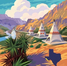
Over the next 15 miles, we wandered down to the river at the old Contrabando movie set and checked out the landmark TxDOT tepee picnic area that lies at the foot of La Cuesta—The Hill—whose 15 percent grade is a severe test for trucks and RVs. Park at the top and get out for an incredible view: Texas’ Bofecillos Mountains to the north, Mexico’s Mataderos Mountains to the south, the Rio Grande rolling through Dark Canyon some 600 feet below.
Six miles later, it was an easy, quarter-mile hike from a dirt parking lot to Closed Canyon. It’s safe to walk about half a mile on the smooth, water-worn canyon floor—and then, slick, treacherous footing at an 8-foot pour-off prohibits further passage.
Beyond Presidio the road curls some 35 miles into tiny Ruidosa where the ruins of the Sagrado Corazon de Jésus (Sacred Heart of Jesus) Church are being restored. According to the Texas Historical Commission, the church was constructed in the early 20th century, and its rounded, graceful arches—rare features in adobe construction—are probably the largest of their kind remaining in the state.
Twelve miles later, the pavement ends in Candelaria where a mysterious dirt road named Chispa Drive is marked with a green street sign in the middle of the desert. All-terrain vehicles are best suited for this rough and rocky public road that stretches some 50 miles to U.S. Highway 90, northwest of Valentine, and closes when the Rio Grande floods. For road conditions, contact the Presidio County sheriff’s office.
——————–
Camille Wheeler is staff writer for Texas Co-op Power.