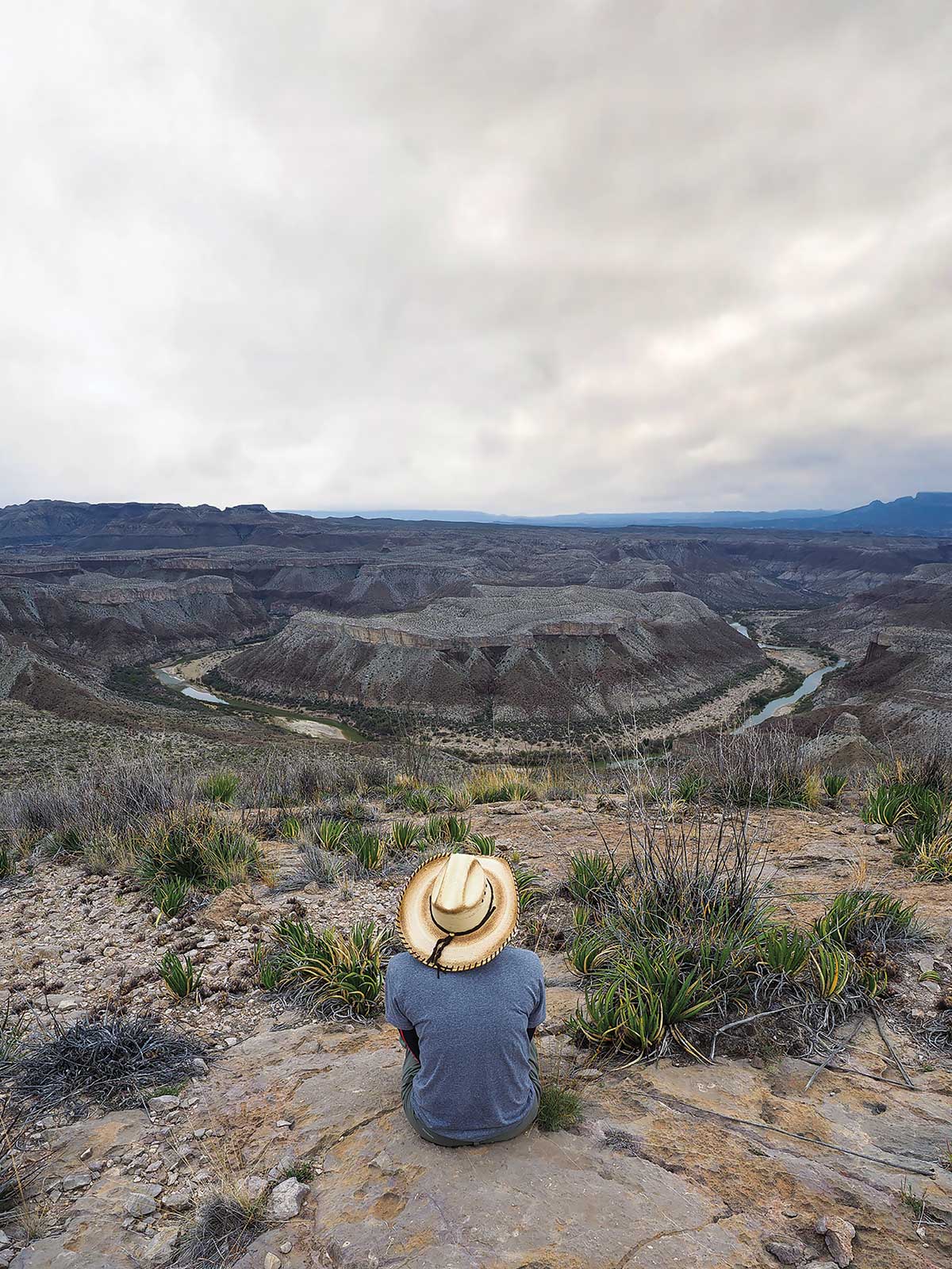
From my vantage point on the side of a rocky slope high above the Rio Grande, the river looks like a glinting horseshoe far below.
I think it’s the best view in the Big Bend region, and that’s saying a lot. I’ve spent hours gazing down at the rippling desert floor from the South Rim, watching the sun sink behind the Window in the Chisos Basin and peering upriver at Santa Elena Canyon.
But this view, from the western edge of Mesa de Anguila, surpasses all of those, and few hikers make the trip. The mesa, an 11-mile hump of land that juts like a broken pinkie off the western side of Big Bend National Park, is one of the least-visited areas of the park.
I first discovered the overlook six years ago, during a challenging multiday backpacking trip down the spine of the mesa. Now I make a much easier 2.5-mile jaunt to reach the overlook.
Here, the desert closes in for a prickly hug. With its shattered rocks and cactuses that look like bouquets of steak knives, this remote spot feels like the backdrop of an old Star Trek episode.
You’ve probably seen photographs of Horseshoe Bend at the Glen Canyon National Recreation Area in Arizona, where Instagrammers famously flock to snap photos of themselves high above a U-shaped section of the Colorado River. This, to me, is the Texas equivalent.
To get here from the park’s west entrance, drive 21 miles west along FM 170 to Lajitas. The Mesa de Anguila Trail starts behind the Lajitas Golf Resort, next to a sign that says, “Poisonous snakes and insects may be present.”
The first mile and a half of the trail zigzag through flat desert, dipping into shallow arroyos and winding past scrub. There is no shade; bring plenty of water, even in winter.
After about 30 minutes plodding through the desert, the trail starts to climb up a rocky gully. You’ll get a quad-burning workout as you ascend 600 feet over half a mile. You might need to use your hands as you clamber over rocks as big as armchairs and tiptoe through spillways of scree.
When you reach the saddle at the top, just past the 2-mile point, the main trail continues straight. Instead of following that path, look for a faint trail to your right. Make your way up the hill, then look south, toward Mexico.
Voilà.
Find a good boulder to sit on, and take it in. I could sit for hours, contemplating the way the river embraces the land.
They say horseshoes bring good luck. In this case, I’m sure it does. Anyone who makes it to this spot is lucky to take in such a beautiful view.